
Monthly Beach Mapping
October 1, 2014 by Chris Hein
Gloucester Point, VA
One of the primary goals of this project is to understand what is driving the natural cycles of beach erosion and widening (what coastal geologists call “accretion” or “progradation”). The first step is to get a quantitative handle on just how much sand is moving onto, off of, and along the beach due to natural seasonal cycles.
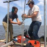
To that end, my masters student, Andy Fallon (shown on the right walking with project investigator Peter Rosen along the dune toe in front of Annapolis Way), is mapping the Plum Island beach on a monthly basis using a Global Positioning System with Real-Time Kinematics (RTK-GPS). Once a month, early in the month, you will find Andy out there walking the beach with a rod with what looks like a small UFO on top. He is carrying around a “rover” antenna on top of a rod of known height. This antenna talks (via radio) to our “base station” antenna that is generally set up on a tripod on the deck of a Plum Island homeowner (Bob Connors of Annapolis Way – thanks Bob!). The base station sits for hours at a time and constantly improves its positioning accuracy. It then corrects the data from the rover. The end result? Andy can record his position as well as the elevation of the antenna to within about 1 inch (your car GPS is accurate to about 10 feet . . . though the elevation can be off by dozens of feet). He collects that data every 1 foot that he walks, collecting tens of thousands of data points along the dune toe, the low tide line, several lines along the beach in between, and then a series of “crossing lines” that he walks diagonally between the dune toe and the low tide line.
From these data, Andy is going to create high-resolution topographic maps (what we call “digital elevation models” or DEMs) of the 1.6 miles of beach from the jetty at the mouth of the Merrimack River all the way south to the border between the town and the Parker River National Wildlife Refuge. Check out the first example, from May 2014, in the figure below. By comparing these maps from different months, we will be able to look at how the beach is changing during the seasons and actually calculate with high precision the volumes of sand that move onshore, offshore and alongshore during the year. This will give us a first clue into the natural changes along the beach due to winter storms, hurricanes (though we are all hoping we don’t see one of those this year!), and calm-weather beach-building processes, like those bars of sand that you would see moving onshore if you were out on Plum Island at low tide this week.
The image above shows a map of Plum Island showing elevation data collected in May 2014 along northern Plum Island. The right-hand side of the image shows a three-dimensional view of the beach at that time. Warm colors are higher elevations and cold colors are low elevations. Note the deep erosion right in front of Annapolis Way at the erosion “hotspot”. Figure is from: Fallon, A.R., Hein, C.J., and Rosen, P.S., submitted abstract, Cyclical shoreline erosion: The impact of a jettied river mouth on the downdrift barrier island: Coastal Sediments 2015 (San Diego, CA, May, 2015).
 June 14, 2015 - Rowley House, Rowley, MA One week down . . . one to go. Claudia, Justin, and I are at the half-way point of a major […]
 May 15, 2015 - Williamsburg, VA I am just back from beautiful, sunny San Diego! Andy Fallon and I were out there all of this past week at the […]
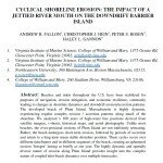 Posted: May 15, 2015