Dispatch from the Field
June 14, 2015 by Chris Hein
Rowley House, Rowley, MA
One week down . . . one to go. Claudia, Justin, and I are at the half-way point of a major field work excursion to Plum Island. Work on lots of different projects going on this time. For once, we’re actually not working on the beach itself. Instead, we’re in the marshes and tidal flats of Plum Island – the Great Marsh – the region of a barrier island system generally called the “backbarrier”.
Not only is the marsh a vital economic and environmental resource, but the sediments in the backbarrier can tell us a lot about Plum Island itself. For example, think about the sediments feeding the island. All of that sand is coming down the Merrimack River. Along with it is fine sand, silt, and clay. These sediments become sorted in the Merrimack River estuary, with the coarse material making it out the beach and the finer becoming trapped in Joppa Flats and the Great Marsh. We can look at the deposition rates of sediment in those systems and they can tell us something about the rates at which sand is making it to Plum Island over the past few hundred years . . . and how humans have changed that rate through things like deforestation (during the Colonial period) and the building of dams along the river.
So, that brings us to our work in the backbarrier! This past week we’ve tackled two major projects. The first involved again pulling out our Geoprobe drill rig and collecting more sediment cores along the back side of Plum Island. You can see some photos from last year’s drilling effort here. We made a few tweaks to the system and this year we hit 75 feet deep! Through the entire barrier island sequence (barrier dunes and beach sands, through 3000-year-old marsh and thousands of years of backbarrier sand) and into the underlying glacial deposits (the glaciomarine clay known around here as the “Boston Blue Clay”, which was deposited some 17,000 years ago). This is what we wanted – get through all 75 feet of Plum Island so we can use organic chemical tools called “biomarkers” to study where that sand is from. Claudia & Justin had a great write-up of their process of opening and describing last year’s cores – see that in this old blog here.
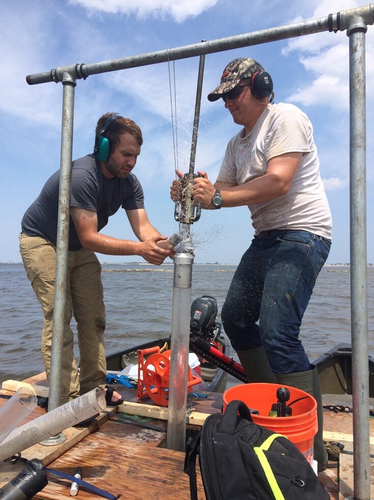
Justin and Zach collecting a piston core in the sediments of Joppa Flats.
On Wednesday and Thursday, Andy and Zach (now a masters student at UMass) joined us and we collected a series of “piston” cores in Joppa Flats. The system is neat – we strapped together two canoes with a piece of plywood between them. A hole in the middle of the plywood between the canoes allowed us to core into the sand and mud of Joppa Flats even during high tide. Our cores, which were up to 7 feet long, record hundreds of years of sedimentation – basically, the sand and mud that was coming down the river when Europeans first arrived in northeastern MA.
After a quick jaunt this weekend up to Maine to run some ground-penetrating radar along a 5000-year-old channel of the Kennebec River (I’ll tell you about this some other time), we’re back in Rowley on a beautiful Sunday evening. Tomorrow, we start round #2 for this trip. Collecting more cores! This time only ~ 3 ft long cores in the man-made freshwater ponds on the Refuge. We’ll also be helping our colleagues to collect instruments that have been out in the tidal channels of the Great Marsh for the last month collecting wave, tide and current data. You might also see us out taking a few short cores in the marsh itself – studying how fast those have been growing over the past 100 years. Look for us on Wednesday (I think) north of the Plum Island Turnpike, on the Plum Island side of the bridge over the Plum Island River.
The VIMS crew stands out . . . we have a big VIMS truck. Feel free to stop by and say hello if you see us working or driving around the area.
– Chris, Claudia, & Justin


 December 2, 2015 - VIMS, Gloucester Point, VA As the title says, it’s been a while. Sorry about that – this semester has been very busy. But, I wanted […]
 August 26, 2015 - VIMS, Gloucester Point, VA The VIMS team is back home after a lot of field work and meetings this summer . . . and none […]
 Posted: February 21, 2016
 Posted: December 2, 2015