
More on the Stability of Plum Island (or the instability of Virginia barrier islands)
February 18, 2017 by Chris Hein
Gloucester Point, VA 18 February 2017
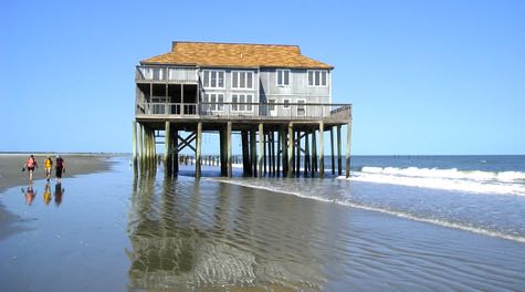
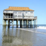
Back in the fall, I wrote about why Plum Island is so unique: it doesn’t move. It has been largely robust and stable for thousands of years. That is not so much the case down here in Virginia, where our barrier islands are eroding and/or moving landward on the order of 15 feet per year! That house pictured here (courtesy of Woody Hobbs of VIMS) on Cedar Island in the late 2000s? Long gone. Its pilings are out in deep water: they stayed in the same place, but Cedar Island moved underneath it.
Because of all of the sand delivered to the barrier island from the Merrimack River, large-scale erosion and migration of Plum Island is not at all a problem. Thus, it can be developed with the towns of Newbury and Newburyport, and the dunes, marshes, beaches, and wildlife habitats of the Parker River National Wildlife Refuge.
My research group recently published a paper in Geology about the erosion and migration of the Virginia barrier islands and the implications for the local marshes: 10% of these marshes have been lost in the last 15o years due to barrier islands moving on top of them, and then the marsh popping out in the surf zone on the front side, eventually to be eroded away.
VIMS also built a very nice website highlighting the results of our work on the Virginia barrier islands (paid for in part by the same National Science Foundation grant that funds the Plum Island Research Project). You should really check it out: Barrier-island migration drives large-scale marsh loss
I think you will come away from this with a whole new perspective on Plum Island, and why it is so different from barrier islands elsewhere in the world. Working down here in Virginia certainly taught me that lesson!
For more, check out these articles from the press down here in Virginia:
VIMS salt marsh study finds barrier island migration a threat
Virginia barrier island change featured on WVTF Radio IQ (Blacksburg, VA).
The Viginian-Pilot
WAVY News
WINA Radio, Charlottesville, VA.
Relevant Article
by Chris Hein
Williamsburg, VA 17 February 2017
NPR published today a very thought-provoking and relevant article (also heard on All Things Considered) about coastal erosion, climate change, and resilient communities. It is focused on Nahant, rather than Plum Island, but the same lessons apply. Check it out here: In Massachusetts, Coastal Residents Consider How To Adapt To Climate Change
The Remarkable Stability of Plum Island
October 24, 2016 by Chris Hein
Gloucester Point, VA 25 October 2016
I received an email yesterday from friend of the project and local science author Bill Sargent (author of this recent book on the geologic and human history of Plum Island), and it really drove home to me something very unique about Plum Island . . . it doesn’t move.
|
Chris Hein & Andy Fallon collecting a core through 2000-year-old marsh near Sandy Point State park, Plum Island, MA. |
You see, Bill found on the beach of Castle Neck some prehistoric oyster shells. They washed up on the beach probably after being eroded from somewhere else in the Plum Island / Coffin’s Beach system. We don’t know quite where and we have not yet dated them (using 14-C or “radiocarbon” dating) to see when they first formed, but it is possible they have been around for thousands of years. They formed alongside the marshes and tidal flats behind the barrier islands, and were probably buried by sand thrown up and over the dunes during a big storm. This process, called “overwash”, and I wrote about how it doesn’t really happen much on Plum Island in a blog post two years ago.
But, overwash once DID happen. In fact, Plum Island used to be much less stable than it currently is. 4000-5000 years ago Plum Island was a set of small, narrow islands that migrated landward, covering the marsh and bays behind it. Eventually, due to both a decrease in the rate of sea level rise and the continued delivery of sand from the Merrimack River, the island stopped moving landward, stabilizing in its current position ~3500 years ago. It stopped overwashing and burying marsh, and by 2500 years ago had started instead building wider and higher; this was the topic of my 2012 paper on Plum Island written as part of my PhD work.
So, about those oyster shells Bill found . . . well, those may have been eroded out of the modern beach of Plum Island, after having been buried for 2500 years or more. How do we know this date? Well, a few years ago, Andy Fallon & I collected some samples of marsh that we found in the surf zone on southern Plum Island, at the beach near Sandy Point State Park. This summer we dated that marsh with radiocarbon dating and found that it is ~2100 years old. In other words, Plum island migrated landward (west), buried that marsh – which was on the back side of the island – 2100 years ago, and then sat there on top of that marsh for all that time in between. Only now, a little erosion at the southern end of Plum Island has excavated that marsh, this time on the FRONT of the island.
|
Young ( |
This happens all over the place. Down in Virginia where I spent a lot of my time studying barrier islands, you can find marsh popping out on the beach on almost every barrier island. The difference? That marsh is only 50-100 years old, as opposed to >2000 years as we find on Plum Island!
So, what’s the difference? Well, despite what appears to be very severe erosion on Plum Island which has caused the loss of ~8 houses over the last 10 years, Plum Island is a very stable barrier island. It DOESN’T move! It has been sitting in the same place for literally thousands of years. Compare that to Cedar Island in Virginia: that beach retreats landward at a rate of ~30 feet per year.
Why? Well, we can thank the Merrimack River: that river has been pumping out large quantities of sand for thousands of years . . . . 12,000 years ago it was much more than today, and the amount of sand is less today than it was in 1800, before all of the dams on the river. But, it still delivers ~38,000 yd3 of sand every year, That sand gets reworked along the beach, nourishing it naturally, and helping the beaches and dunes of Plum Island keep up with rising sea level.
Down in Virginia we have no such river feeding our barrier islands. Their sand comes from erosion of cliffs . . . in Delaware. Without a fresh supply of sand from a river, those barrier islands erode and migrate . . . and not coincidentally, there are no longer any communities living out there.
So, go ahead and check out those ancient oysters on Castle Neck. Drive down to Sandy Point, walk to the beach at low tide, and look for the 2000-year-old marsh partially buried in beach sand. And think about just how remarkably stable Plum Island actually is . . . and the real challenges it would face if not for the Merrimack River.
A Mid-Autumn Update
October 23, 2016 by Chris Hein
Williamsburg, VA 23 October 2016
The high temperatures finally fell below 80 degrees down here in Virginia and the leaves are maybe just starting to think about changing. We also dodged a huge bullet with Hurricane Matthew last week, though neighbors in Virginia Beach did not make out so lucky, and that is to say nothing of the damage and loss of life and property further south in the US and utter devastation in Haiti.
Hurricane Matthew did nothing to Plum Island, having never really made it up that far north. Same with Hermine, Gaston, Lisa, etc. In fact, it has been a quiet year on Plum Island in terms of storms and the erosion they cause. Of course, we’re just about to start heading into nor’easter season, so that may soon change. I encourage you to check out my blog post from a few years back talking about what we might expect heading into the winter season.
I’ve been quiet too, as the team has been working on a range of projects associated with Plum Island. Just what have we been up to? Well, here are some highlights from this past summer:
- Rebecca Whitney completed an awesome Research Experience for Undergraduates (REU) project looking at down-core sediment records from our Plum Island Geoprobe cores. She studied 9000 years of sediment deposited under Plum Island to learn more about where it is from and the processes that deposited it. The short answer? Something big changed ~6000 years ago when sea-level rise slowed. The entire nature of the sediment forming Plum Island shifted, and likely came more from the Merrimack River than offshore, the dominant source earlier.
- Sarah Baker has been working hard on her study of erosion at Plum Island Point. She has been mapping old shorelines (guided in part by Mike Morris of Storm Surge and we sampled sand from the entire Plum Island Point region back in early July to track how the sand changes away from the inlet . . . and try to figure out how much of the sand that builds up Reservation Terrace and Plum Island Point is moved from the south, through holes in the jetty.
- Jenn Connell has been processing and analyzing sediment from cores in the marsh behind Plum Island. She is using a tool called radioisotopic dating (and specifically lead-210 dating) to determine how fast the marsh has been growing over the past 100 years.
- Charlie Deaton had his closely related study of barrier island change in Virginia accepted for publication. I’ll be writing a new post on this just as soon as that if formally published and we can share these very neat results.
- Justin Shawler has been writing up the results of his honors thesis, which he defended back in May. We’re hoping that will be submitted for publication soon and we’re very excited to share those results soon. There is a very neat story about how European colonists right up through modern communities along the Merrimack River have been impacted the amount of sand that makes it to the beach each year.
- I’ve been working lately with other team members on proposals to allow us to expand and continue our work on Plum Island. As any good science does, this project has raised just as many questions as answers of earlier questions it has provided.
I’ll be posting updates on each of the above points soon. Keep checking back over the next weeks to months.
However, in the real near future, we’ll be posting to this website the first webisode from our documentary film. CHECK BACK in just a few days for that. We’re thrilled to share it with the Newbury, Newburyport, and global community that follows this blog.
Stay warm out there.
– Chris
The Wagging Tail of the Merrimack River
February 21, 2016 by Chris Hein
Williamsburg, VA 21 February 2016
Picking up where I left off yesterday . . .
So, I’ve shared some of my perspective about the need for sound science to inform management of northern Plum Island and the erosion problem at Reservation Terrace. It has been suggested by some residents and some in the local media that removal of the jetties (or at least the south jetty) will remedy this situation and/or help the erosion problem along Annapolis/Fordham Way. As part of our study of Plum Island, we’ve looked into just this. Well, not directly . . .
One of the key tenants in geology is that the present is the key to the past. Put another way, the past (that is, what we can learn from the historic and geologic / sediment records) is the key to the future. What does that have to do with the erosion at Plum Island Point? Quite a bit.
If you look at historic maps of northern Plum Island, you’ll see that it has not always looked like it does, with two “forks” separated by the Basin. In fact, the entire northeast end of Plum Island is ephemeral over 10s to 100-year timescales: it builds, gets eroded away, rebuilds, and so on. Prior to the installation of the jetties to stabilize the mouth of the Merrimack River, this happened at least twice since Europeans settled the lower Merrimack Valley. Check out the maps (and my annotated interpretations) below.
Historic maps (top) and annotated diagrams (bottom) of the changes at northern Plum Island from 1741 to 1883 (installation of the jetties).
Over time, the Merrimack River, like most un-jettied tidal inlets, “wags”, like the end of the tail of a dog (or cat, if you prefer felines [I do]). Why? Well, it comes down to the two big forces along the coast: tides and waves. Tides work cross-shore, moving water and sediment through breaks in the beach / barrier islands (tidal inlets) between the ocean (the Gulf of Maine in this case) and the “backbarrier” (the marshes, tidal flats, lagoons, and estuaries landward of the barrier island; the Merrimack River mouth in this case). Tidal forces want to move water back and forth and quickly and efficiently as possible. The fastest route between the backbarrier and the ocean is the same as the shortest distance between two points: a straight line. In the case of northern Plum Island, that means that the Merrimack River would go almost straight east-west.
The other major force along the coast is waves. Well, waves just come from offshore and strike the beach head-on right? So they are moving water (and therefore the energy to move sand around) in the same direction as tides (cross-shore), right? Not quite. Recall any time you’ve been swimming at the beach for a while and notice that when you come out of the water, you have been moved down along the beach (parallel to the beach) from where you left your towel. That is a process called “longshore transport” and it is due to the fact that waves do not strike the beach straight-on (in most cases), but instead arrive from a slight angle to the beach. They tend to straighten out as they approach the shore and break, but they still retain a bit of an angle . . . enough to move you, or sand, along the shore.
Over longer periods of time (months to years or longer), sand grain by sand grain, this can move large amounts of sand, and alter the shape of the coast. Sand gets trapped on the “downdrift” side of groins (the side from which waves are coming) and it gets moved far down the beach (this is why when one person uses hard structures to trap sand in front of their beach, or prevent erosion of a bluff, someone further “downdrift” is being robbed of sand that doesn’t make it to them, and they start to experience erosion). Mike Morris covers this topic very well on his website, with a lot of nice graphics: http://www.plumislanderosion.com/
Although Mike and I disagree on the importance of southerly swell (waves from the southeast, roughly) along particular sections of the Center Island to Annapolis Way sections of Plum Island, we do agree that longshore transport plays a major role in the changes we see along this beach. We also agree that, over long periods of time (decades to centuries to millennia) waves from the northeast play a dominant role in shaping the island; that is why Plum Island has grown as a spit to the south over the last 4000 years. Southerly longshore transport by waves from the northeast (dominantly during our winter nor’easters which have some of the biggest waves during the year) is also how Cranes & Wingaersheek Beaches obtained their sand, which, by the way, is all from the Merrimack River.
Ok, so what does this all mean for the mouth of the Merrimack River? Well, those tidal forces are working to keep it as straight as possible: east-west. Waves are working to shift its position. Over time periods of decades, that shift is always to the south: the mouth is literally pushed to the south as the spit of Salisbury Beach grew to the south. This, of course, causes the Merrimack River Inlet to impinge upon northeastern Plum Island, causing massive erosion. How massive? Well, prior to those jetties, the southwesterly migration of the Merrimack River mouth wiped out the entire northeast fork of Plum Island (called “Old Point”) in the early 1800s. It eroded down to roughly the position of 16th Street. Nothing north nor east of there existed (those areas were all open water). As late as ~1840, the Merrimack River ran right through the Basin and under where Mad Martha’s (yum! by the way) sits today.
That’s right, the Basin is the old channel of the Merrimack River.
So, what happened? Well, eventually, the Merrimack River got too far southeast: those tidal forces, which work to give the river the shortest route to the ocean, became too strong for the wave forces. The Merrimack River blew through southern Salisbury (possibly during a big storm) and created its current channel. This is a very common process at tidal inlets; it is called “ebb-delta breaching” because the river/inlet cuts through its ebb-tidal delta (that area of shallow water offshore of the river mouth we now call “The Bar” or “The Breakers”) to give itself the shortest route possible to the ocean.
After this breaching event, a large bar of sand (which had been the ebb tidal delta of the Merrimack before the breaching event) was free to move, and it migrated onshore, eventually building up to become the northeast fork of Plum Island. Some of the former river channel was filled (hence our ability to go to enjoy those awesome omelets at Martha’s), but the rest of the channel was left behind as a long, narrow body of water that still looks like the river channel it once was: The Basin.
Soon after this last breaching event, the US Army Corps built the jetties and stabilized the mouth of the Merrimack and allowing for further growth of “New Point” (the northeast fork, including, of course, Plum Island Point which is today eroding). That put an end to the natural “wagging” of the Merrimack River, though started a pattern of erosion that comes and goes along the Newbury portion of Plum Island beach and at Plum Island Point . . . that part is a story for another day.
Using the tools of sedimentology and geology, we went back to this area to check and see if we could find evidence of this series of events. And did we ever! Using a tool called “ground-penetrating radar” (GPR) which sends a radar signal into the ground from a little antenna and allows scientists to “see” into the subsurface, we imaged the old river channel under 16th St. The series of dipping lines you see in my annotated figure below (with the actual data above it) is a bar of the Merrimack River channel growing as the channel migrated. We took a sediment core through this with our Geoprobe Drill Rig back in May 2014 . . . the pebbles and gravel we see at the bottom of that bar are from the Merrimack River bottom – this confirms that we we found is indeed the early 1800s Merrimack River.
Ground-penetrating radar profile of the former Merrimack River channel, as imaged under 16th Street. The section shown in blue is the former channel. The elevations to the left are in meters with respect to mean sea level. On the right the “depth” in the profile is given in TWTT, or two-way travel time.
I’ll be presenting our findings to a large international meeting of coastal scientists in Australia in a few weeks. As part of this study we compared what we know about the Merrimack River ebb-delta breaching from the historic maps and what we can see in GPR and sediment cores to the GPR and sediment signatures of a 3600-year-old tidal inlet I discovered in central Plum Island back in 2012. One inlet is 150 years old and associated with the Merrimack River . . . the other is 3600 years old and associated with the Parker River when it once shot straight through Plum Island and out to the Gulf of Maine. Cool . . . at least I think so.
I posted a copy of the scientific poster I made for this meeting here. Check it out and let me know ([email protected]) if you have any questions.
On last interesting facet of this study is that this series of events I’ve described which formed The Basin and Plum Island Point is not new. In fact, this likely happened many times in the past. Check out those maps above again: Old Point was only starting to form in 1741, probably very soon after the previous ebb-delta breaching event and re-orientation of the Merrimack River mouth. We don’t have data prior to the early 1700s, but I would guess this happened over and over, probably once every 50-100 years or so.
If you want an example of how this STILL occurs, just check out a “natural” inlet (one with no jetties). Time Magazine’s Timelapse (http://world.time.com/timelapse/) is a great tool to view 30 years of satellite imagery: you can really watch the coast change before your eyes. Just click on the “Explore the World” link on the bottom right of the main image on that page and then type in “Chatham, MA” and hit enter. That is not ebb-delta breaching, but you’ll get a great sense of just how dynamic the interaction between waves and tides at natural tidal inlets can be.
I know this is a dense post, but we’re all very excited by these results and wanted to share them with our readers of this blog. We’re at the point in this project where we have results and conclusions coming hot and fast and we look forward to posting more of them soon, so check back. In the meantime, I hope this all made sense and hopefully sheds some light on just what northern Plum Island would be doing if not for those jetties . . . and therefore maybe add a bit more science, as learned from the history of Plum Island, to the current debate over how to address the severe erosion at Plum Island Point.
— Chris
Plum Island Point Erosion
by Chris Hein
Gloucester Point, VA 20 February 2016
There has been a lot of well-founded concern and quite a few news articles lately about the erosion on Plum Island Point (Reservation Terrace), the section of northeast Plum Island that resides northwest of the South Jetty and effectively within the mouth of the Merrimack River Inlet. See, for example here and here.
Theories as to why this is occurring generally point to the recent repair work on the south jetty and include the plugging of of a “river of sand” from the beach south of the jetty, up through the jetty and into the Point. Another idea proposed has been that repairing the jetty has allowed the jetty to do, well, what jetties do: narrow the river, constricting the flow of water that passes through during the flooding and ebbing tides, and forcing that water to move through faster (I think back to high school physics: a volume of water flowing from a wide pipe into a narrower pipe will have to speed up due to the pressure of the water moving in from behind it). The faster water moves, the more sediment it can carry, and the more erosion it can cause.
Both of these are entirely plausible theories. In fact, they both might play a role. Proponents of each point to times in the past when the jetty was repaired and there was erosion on The Point. I, personally, do not have the data to support or refute either. However, one of the key rules of science is that correlation does not mean causation. In other words, just because there appears to be a coincidence of timing between the jetty repair work and the erosion, does not mean that the former caused the latter. Of course, it also doesn’t mean that the jetty repairs didn’t cause the erosion . . .
There have been calls for a proper scientific study of this deeply disconcerting issue. As a scientist who has been studying Plum Island since 2007 (first the formation of the island over the past 6000 years, and in the last two years the erosion along Center Island through Fordham Way), I, of course, could not agree more. Science needs to play a central role in planning for the short-term (how to deal with the erosion issue occurring now to ensure no homes are threatened?), the medium-term (how to better engineer northern Plum Island to best ensure the viability of both The Point and the areas threatened in Newbury?), and the long-term (what are the local threats from climate change [for example, in terms of storms and sea-level rise] and how do we best plan for mitigation or, as recently proposed by local author Bill Sargent). I’ll stress that the decisions on solutions are political and social, not scientific, but they should use the best science available. Right now, that science is not available on the Plum Island Point erosion issue. Believe me, though, I know how the generally slow pace of science can feel when you house is threatened. My personal opinion (not necessarily that of this research team, VIMS, NSF, etc) is that there is a political need to seek a short-term solution to ensure against property damage from the current erosion, though that should be a temporary “soft” engineering solution.
So, all that said, there is another aspect of this that the science I and my team have been doing CAN address: that is the suggestion that has been made that the jetties (or at least the south jetty) be removed. Again, the decision to do so is societal, not scientific. However, as part of the Plum Island Research project, we do actually have some neat data to share that can tell us a lot about what may happen to northern Plum Island if the jetty (or jetties) were to be removed. I’ll be presenting it in a few weeks at an international meeting. Look for a new post tomorrow in which I’ll share details and a copy of the scientific poster!
— Chris
It’s Been a While . . .
December 2, 2015 by Chris Hein
VIMS, Gloucester Point, VA
As the title says, it’s been a while. Sorry about that – this semester has been very busy. But, I wanted to share with our readers some really great updates.
As I mentioned in my last post, we’re now deep into the data processing, analysis and writing from our two years of field data collection on Plum Island. To that end, we’ve starting sharing some of our results with the scientific community.
W&M senior Justin Shawler presented preliminary results from his investigation of sediment accumulation rates in Joppa Flats (the Merrimack River Estuary) at the national meeting of the Geological Society of America in Baltimore, MD back in early November. I’ll be sure to ask him to write up a blog post over the holiday break, discussing some of what he’s found.
Then, yesterday was a real big day around here: Plum Island Research & VIMS student Andy Fallon successfully defended his masters thesis. Our congratulations to Andy! (check out the photo below of him all suited up). You’ve seen posts from Andy here before, talking about his monthly beach surveys (ended in March 2015). That was only part of his work: with the help of W&M graduate Haley Gannon, he also mapped the northern Plum Island shoreline going back to the early 1900s to explore the causes of the cycles of erosion and beach building that so many have observed. With Porter Hoagland of the Woods Hole Oceanographic Institution, Andy also constructed a hedonic price model to look at how the local housing market responds to erosion and erosion-control structures like groins and seawalls. Really neat stuff. Now, Andy has a bit of work to do on edits before the final thesis is due next week, but we’re looking forward to getting both of those studies published soon. In the meantime, I’ll also ask him to write on this blog about some of what he found.
In the meantime, Ju-Chin & Wei continue data analysis from their surveys last year and I know Wei is writing up his PhD thesis. Work continues here at VIMS on sediment cores and associated geochemical analyses to look at the source of the sand and mud that make up Plum Island. And, we now have our first data (210-Pb & 137-Cs, for those interested) that will allow us to explore how humans have altered marsh growth rates throughout the Great Marsh in the last ~100 years.
Looking towards next year, we’re hoping that I and/or some of the team will be able to get back up to Newbury/Newburyport to give a public talk on some of our findings: we think they will provide some very useful insights in planning for future climate change (yeah, and about those talks in Paris . . .).
Finally, I’ve joined the 21st century and started using Twitter for scientific communication! Follow me: @coastalgeology.
Look for more from us around the holidays and into the new year. For now, it’s back to work for me on that final exam for my students next week . . .
– Chris
Science!
August 26, 2015 by Chris Hein
VIMS, Gloucester Point, VA
The VIMS team is back home after a lot of field work and meetings this summer . . . and none of us is quite ready to start classes TODAY!
However, I for one can say this was a very productive summer for our work on the Plum Island Research Project. We collected cores from across the Great Marsh to determine how fast the marsh is growing in different areas and if it can keep pace with an ever-faster rising sea level. We finished our deep coring across Plum Island and now have cores going down 72 feet below the island surface – down into sand and mud laid down 15,000 years ago (Claudia is now working up these cores in the lab – check out her post from this past winter describing how she does this). We collected a series of cores across Joppa Flats to look at the record of human influences on sediment supply down the Merrimack River. We collected yet MORE cores in the marsh behind southern Plum Island in collaboration with the Parker River National Wildlife Refuge to look at the possibility of opening up parts of some of the freshwater ponds to salt water. AND, we worked with a larger team from Boston University and the University of New Orleans on collecting hydrodynamic (wave & tide) data for a model being developed as part of a multi-institution project funded by the Hurricane Sandy Relief Fund.
In other words, it was busy and all of those data give us A LOT to do over the next months as we work up samples in the lab and data on our computers. Yep, gonna be a long winter – but I’m psyched for the discoveries to come and to sharing them with the community around Plum Island.
However, for me, the most exciting part of this summer was a two-day meeting we held at the Refuge Headquarters in mid-August. This was the whole Plum Island Research Project Team – nearly 20 of us in total, with some excellent guest speakers (Annapolis Way homeowner Bob Connors, Storm Surge Chair Mike Morris) to boot. Each team presented their results to date – great findings about the cycles of erosion, human impacts on the Merrimack River Valley and Plum Island, chemical signatures of the Merrimack River found in sediment cores, economic analyses of how housing values on Plum Island change in response to shifting erosion, public perceptions of the erosion problem and what can & should be done, and a list of potential policy prescriptions. I think every one of us came away very excited about the range of findings and what we hope we can add to the discussions about the future of Plum Island.
We’ll have more to share publicly in the spring as we complete analyses, but keep checking back here over the next months for more updates – we look forward to sharing them all..
– Chris
Recent Posts
Relevant Article
February 18, 2017 - Williamsburg, VA 17 February 2017 NPR published today a very thought-provoking and relevant article (also heard on All Things Considered) about coastal erosion, climate change, […]
The Remarkable Stability of Plum Island
October 24, 2016 - Gloucester Point, VA 25 October 2016 I received an email yesterday from friend of the project and local science author Bill Sargent (author of this […]
A Mid-Autumn Update
October 23, 2016 - Williamsburg, VA 23 October 2016 The high temperatures finally fell below 80 degrees down here in Virginia and the leaves are maybe just starting to […]
Recent Library Uploads
More on the Stability of Plum Island (or the instability of Virginia barrier islands)
 Posted: February 18, 2017
Gloucester Point, VA 18 February 2017 Back in the fall, I wrote about why Plum Island is so unique: it doesn’t move. It has been […]
Relevant Article
Posted: February 18, 2017
Williamsburg, VA 17 February 2017 NPR published today a very thought-provoking and relevant article (also heard on All Things Considered) about coastal erosion, climate change, […]
The Remarkable Stability of Plum Island
Posted: October 24, 2016
Gloucester Point, VA 25 October 2016 I received an email yesterday from friend of the project and local science author Bill Sargent (author of this […]
Top 10 Must-Do Activities for an Unforgettable Seychelles Honeymoon
Posted: June 6, 2024
Seychelles, an archipelago of 115 islands in the Indian Ocean, is a honeymoon destination with its pristine beaches, crystal clear waters, and lush tropical […]
A Mid-Autumn Update
Posted: October 23, 2016
Williamsburg, VA 23 October 2016 The high temperatures finally fell below 80 degrees down here in Virginia and the leaves are maybe just starting to […]